Description
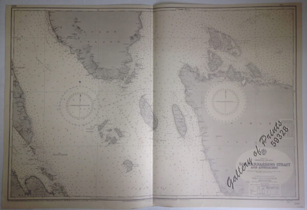
lithograph. Map#3827. Small corrections 1940 [many subsequent years stated till] 1964 – Z.12-59. Seal of the Hydrographic Office – 2 Sea Roses with 360 degrees.

₱11,000.00
1 in stock
lithograph. Map#3827. Small corrections 1940 [many subsequent years stated till] 1964 – Z.12-59. Seal of the Hydrographic Office – 2 Sea Roses with 360 degrees.
with center fold as issued.

![Réprésentation du Cours ordinaire des Vents de Traverse qui regnent sur les Cótes dans la grande Mer su sud [Depiction of the Great Southern Seas Trade Winds from Indochina and Australia to the Americas]](https://galleryofprints.shop/wp-content/uploads/2018/12/JO57854-Dampier-1701-Pacific-Southeast-Asia-AUS-USA-Philippines-1-scaled-1-600x750.webp) Réprésentation du Cours ordinaire des Vents de Traverse qui regnent sur les Cótes dans la grande Mer su sud [Depiction of the Great Southern Seas Trade Winds from Indochina and Australia to the Americas]
₱13,500.00
Réprésentation du Cours ordinaire des Vents de Traverse qui regnent sur les Cótes dans la grande Mer su sud [Depiction of the Great Southern Seas Trade Winds from Indochina and Australia to the Americas]
₱13,500.00
![Dr. A. Petermann's Mittheilungen aus Justus Perthes' Geographischer Anstalt. Herausgegeben von Prof. Dr. A. Supan. - Ergänzungsband XXIV (Heft 110-114). 1895 Inhalt: [Supplement Vol. 24 contents] Nr. 110. Bludau, Die Oro- und Hydrographie der preussischen und pommerschen Seenplatte. Nr. 111. Baumann, Die kartographischen Ergebnisse der Massai-Expedition des Deutschen Antisklaverei-Comités. Nr. 112. Radde und Koenig, Das Ostufer des Pontus und seine kulturelle Entwickelung im Verlaufe der letzten 30 Jahre. Nr. 113. Sapper, Grundriss der physikalischen Geographie von Guatemala. Nr. 114. v. Flottwell, Aus dem Stromgebiet des Qyzyl-Yrmaq (Halys).](https://galleryofprints.shop/wp-content/uploads/2022/03/JO12564-Petermann-1895-Mittheilungen-aus-Justus-Perthes-Geographischer-Anstalt-volume-24-scaled-1-600x750.webp) Dr. A. Petermann's Mittheilungen aus Justus Perthes' Geographischer Anstalt. Herausgegeben von Prof. Dr. A. Supan. - Ergänzungsband XXIV (Heft 110-114). 1895 Inhalt: [Supplement Vol. 24 contents] Nr. 110. Bludau, Die Oro- und Hydrographie der preussischen und pommerschen Seenplatte. Nr. 111. Baumann, Die kartographischen Ergebnisse der Massai-Expedition des Deutschen Antisklaverei-Comités. Nr. 112. Radde und Koenig, Das Ostufer des Pontus und seine kulturelle Entwickelung im Verlaufe der letzten 30 Jahre. Nr. 113. Sapper, Grundriss der physikalischen Geographie von Guatemala. Nr. 114. v. Flottwell, Aus dem Stromgebiet des Qyzyl-Yrmaq (Halys).
₱6,000.00
Dr. A. Petermann's Mittheilungen aus Justus Perthes' Geographischer Anstalt. Herausgegeben von Prof. Dr. A. Supan. - Ergänzungsband XXIV (Heft 110-114). 1895 Inhalt: [Supplement Vol. 24 contents] Nr. 110. Bludau, Die Oro- und Hydrographie der preussischen und pommerschen Seenplatte. Nr. 111. Baumann, Die kartographischen Ergebnisse der Massai-Expedition des Deutschen Antisklaverei-Comités. Nr. 112. Radde und Koenig, Das Ostufer des Pontus und seine kulturelle Entwickelung im Verlaufe der letzten 30 Jahre. Nr. 113. Sapper, Grundriss der physikalischen Geographie von Guatemala. Nr. 114. v. Flottwell, Aus dem Stromgebiet des Qyzyl-Yrmaq (Halys).
₱6,000.00
![Exacta & accurata delineatio cum orarum maritimarum tum etjam locorum terrestrium quae in Regionibus China, Cauchinchina, Camboja sive Champa, Syao, Malacca, Arracan & Pegu… Waarachtige uitworpinghe ofte afbeeldinge van alle die custen ende landen van China, … [Accurate & Detailed Drawing with Borders Maritime and even Terrestrial Places Located in the Regions of China….]](https://galleryofprints.shop/wp-content/uploads/2025/01/JO64654-van-Linschoten-1596-Exacta-accurata-delineatio-cum-orarum-600x750.webp) Exacta & accurata delineatio cum orarum maritimarum tum etjam locorum terrestrium quae in Regionibus China, Cauchinchina, Camboja sive Champa, Syao, Malacca, Arracan & Pegu… Waarachtige uitworpinghe ofte afbeeldinge van alle die custen ende landen van China, … [Accurate & Detailed Drawing with Borders Maritime and even Terrestrial Places Located in the Regions of China….]
₱999,000.00
Exacta & accurata delineatio cum orarum maritimarum tum etjam locorum terrestrium quae in Regionibus China, Cauchinchina, Camboja sive Champa, Syao, Malacca, Arracan & Pegu… Waarachtige uitworpinghe ofte afbeeldinge van alle die custen ende landen van China, … [Accurate & Detailed Drawing with Borders Maritime and even Terrestrial Places Located in the Regions of China….]
₱999,000.00
![Dr. A. Petermann's Mittheilungen aus Justus Perthes' Geographischer Anstalt. Herausgegeben von Prof. Dr. A. Supan. - Ergänzungsband XVIII, 1886-1887 Inhalt: [Supplement Vol. 18 contents] No. 81. Bayberger, Geographisch-geologische Studien aus dem Böhmerwalde. No. 82. v. Schlagintweit, Die Pacifischen Eisenbahnen in Nordamerika. No. 83. Berndt, Der Alpenföhn in seinem Einflufs auf Natur- und Menschenleben. No. 84. Supan, Archiv für Wirtschaftsgeographie. I. Nordamerika, 1880-1885. No. 85. Radde, Aus den Dagestanischen Hochalpen.](https://galleryofprints.shop/wp-content/uploads/2022/03/JO12558-Petermann-1887-Mittheilungen-aus-Justus-Perthes-Geographischer-Anstalt-volume-18-scaled-1-600x750.webp) Dr. A. Petermann's Mittheilungen aus Justus Perthes' Geographischer Anstalt. Herausgegeben von Prof. Dr. A. Supan. - Ergänzungsband XVIII, 1886-1887 Inhalt: [Supplement Vol. 18 contents] No. 81. Bayberger, Geographisch-geologische Studien aus dem Böhmerwalde. No. 82. v. Schlagintweit, Die Pacifischen Eisenbahnen in Nordamerika. No. 83. Berndt, Der Alpenföhn in seinem Einflufs auf Natur- und Menschenleben. No. 84. Supan, Archiv für Wirtschaftsgeographie. I. Nordamerika, 1880-1885. No. 85. Radde, Aus den Dagestanischen Hochalpen.
₱6,000.00
Dr. A. Petermann's Mittheilungen aus Justus Perthes' Geographischer Anstalt. Herausgegeben von Prof. Dr. A. Supan. - Ergänzungsband XVIII, 1886-1887 Inhalt: [Supplement Vol. 18 contents] No. 81. Bayberger, Geographisch-geologische Studien aus dem Böhmerwalde. No. 82. v. Schlagintweit, Die Pacifischen Eisenbahnen in Nordamerika. No. 83. Berndt, Der Alpenföhn in seinem Einflufs auf Natur- und Menschenleben. No. 84. Supan, Archiv für Wirtschaftsgeographie. I. Nordamerika, 1880-1885. No. 85. Radde, Aus den Dagestanischen Hochalpen.
₱6,000.00
 Ports in the Philippine Islands. insets: 1) Luzon I. - West Coast. Manila and Cavite Anchorages. From the United States Government Chart of 1950. with additions and corrections to 1969. 2) Luzon I. - West Coast. Manila Harbour. From the United States Government Chart of 1950. with additions and corrections to 1969.
₱11,000.00
Ports in the Philippine Islands. insets: 1) Luzon I. - West Coast. Manila and Cavite Anchorages. From the United States Government Chart of 1950. with additions and corrections to 1969. 2) Luzon I. - West Coast. Manila Harbour. From the United States Government Chart of 1950. with additions and corrections to 1969.
₱11,000.00
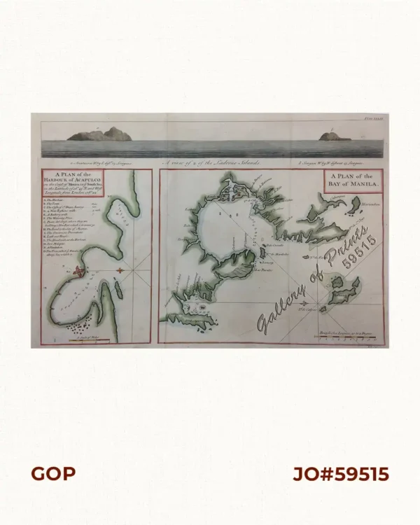 A Plan of the Bay of Manila / A Plan of the Harbour of Acapulco / A View of 2 of the Ladrone Islands
₱39,600.00
A Plan of the Bay of Manila / A Plan of the Harbour of Acapulco / A View of 2 of the Ladrone Islands
₱39,600.00