Description
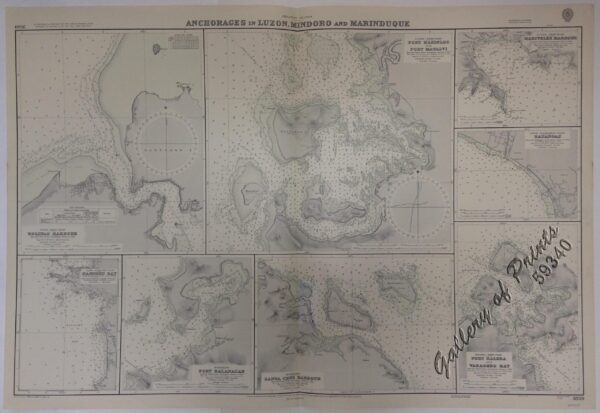
lithograph. Map#3810. Small corrections 1924[many subsequent years stated till] 1966 – Z/c 1965. Seal of the Hydrographic Office – 3 Sea Roses with 360 degrees.

₱11,000.00
1 in stock
lithograph. Map#3810. Small corrections 1924[many subsequent years stated till] 1966 – Z/c 1965. Seal of the Hydrographic Office – 3 Sea Roses with 360 degrees.
with folds as issued.


 Philippine Islands. Tagolo Point to Cuyo Islands. Including Sebu Negros and Parts of Panay and Palawan. From the United States Coast Survey Charts to 1923.
₱11,000.00
Philippine Islands. Tagolo Point to Cuyo Islands. Including Sebu Negros and Parts of Panay and Palawan. From the United States Coast Survey Charts to 1923.
₱11,000.00
![Mittheilungen aus Justus Perthes' Geographischer Anstalt über Wichtige neue Erforschungen auf dem Gesammtgebiete der Geographie von Dr. A. Petermann. - Ergänzungsband IV, 1865-1867. Inhalt: [Supplement Vol. 4 contents] No. 16. Dr. A. Petermann, Spitzbergen und die arktische Central-Region. No. 17. Julius Payer, die Adamello-Presanella-Alpen. No. 18. Julius Payer, die Ortler-Alpen (Suden-Gebiet und Monte Cevedale). No. 19. E. Behm, die modernen Verkehrsmittel. Dampfschiffe, Eisenbahnen, Telegraphen. No. 20. P. v. Tschihatscheff's Reisen in Kleinasien und Armenien, 1847-1863.](https://galleryofprints.shop/wp-content/uploads/2022/02/jo12544-Petermann-1860-Mittheilungen-aus-Justus-Perthes-Geographischer-Anstalt-volume-4-600x750.webp) Mittheilungen aus Justus Perthes' Geographischer Anstalt über Wichtige neue Erforschungen auf dem Gesammtgebiete der Geographie von Dr. A. Petermann. - Ergänzungsband IV, 1865-1867. Inhalt: [Supplement Vol. 4 contents] No. 16. Dr. A. Petermann, Spitzbergen und die arktische Central-Region. No. 17. Julius Payer, die Adamello-Presanella-Alpen. No. 18. Julius Payer, die Ortler-Alpen (Suden-Gebiet und Monte Cevedale). No. 19. E. Behm, die modernen Verkehrsmittel. Dampfschiffe, Eisenbahnen, Telegraphen. No. 20. P. v. Tschihatscheff's Reisen in Kleinasien und Armenien, 1847-1863.
₱6,000.00
Mittheilungen aus Justus Perthes' Geographischer Anstalt über Wichtige neue Erforschungen auf dem Gesammtgebiete der Geographie von Dr. A. Petermann. - Ergänzungsband IV, 1865-1867. Inhalt: [Supplement Vol. 4 contents] No. 16. Dr. A. Petermann, Spitzbergen und die arktische Central-Region. No. 17. Julius Payer, die Adamello-Presanella-Alpen. No. 18. Julius Payer, die Ortler-Alpen (Suden-Gebiet und Monte Cevedale). No. 19. E. Behm, die modernen Verkehrsmittel. Dampfschiffe, Eisenbahnen, Telegraphen. No. 20. P. v. Tschihatscheff's Reisen in Kleinasien und Armenien, 1847-1863.
₱6,000.00
![L'Univers. Histoire et Description de Tous Les Peuples.: Océanie [History and Description of the Peoples of the World] Cinquième Partie du Monde. [Fifth Chapter of the World] Tome Troisième [Third Volume]](https://galleryofprints.shop/wp-content/uploads/2021/08/JO12503-Rienzi-1837-LUnivers.-Histoire-et-Description-de-Tous-Les-Peuples-Oceanie-front-scaled-1-600x750.webp) L'Univers. Histoire et Description de Tous Les Peuples.: Océanie [History and Description of the Peoples of the World] Cinquième Partie du Monde. [Fifth Chapter of the World] Tome Troisième [Third Volume]
₱9,900.00
L'Univers. Histoire et Description de Tous Les Peuples.: Océanie [History and Description of the Peoples of the World] Cinquième Partie du Monde. [Fifth Chapter of the World] Tome Troisième [Third Volume]
₱9,900.00
![Cartas de los PP. de la Compañía de Jesús de la Misión de Filipinas Cuaderno 5o [Letters from the Fathers of the Society of Jesus of the Philippine Mission]](https://galleryofprints.shop/wp-content/uploads/2024/05/JO12685-Cartas-de-los-PP-de-la-Compania-de-Jesus-de-la-Mision-de-Filipinas-front-scaled-1-600x750.webp) Cartas de los PP. de la Compañía de Jesús de la Misión de Filipinas Cuaderno 5o [Letters from the Fathers of the Society of Jesus of the Philippine Mission]
₱8,800.00
Cartas de los PP. de la Compañía de Jesús de la Misión de Filipinas Cuaderno 5o [Letters from the Fathers of the Society of Jesus of the Philippine Mission]
₱8,800.00