Description
lithograph. Map#3816. Large corrections 11th June 1965 Z.5-65. Seal of the Hydrographic Office – 3 Sea Roses with 360 degrees.

₱11,000.00
1 in stock
lithograph. Map#3816. Large corrections 11th June 1965 Z.5-65. Seal of the Hydrographic Office – 3 Sea Roses with 360 degrees.
with center fold as issued.
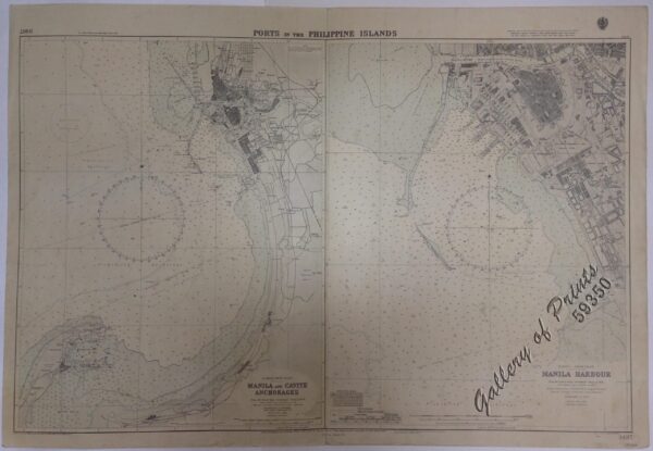 Ports in the Philippine Islands. insets: 1) Luzon I. - West Coast. Manila and Cavite Anchorages. From the United States Government Charts to 1950. With additions and corrections to 1959. 2) Luzon I. - West Coast. Manila Harbour. From the United States Government Charts to 1950. With additions and corrections to 1959.
₱13,200.00
Ports in the Philippine Islands. insets: 1) Luzon I. - West Coast. Manila and Cavite Anchorages. From the United States Government Charts to 1950. With additions and corrections to 1959. 2) Luzon I. - West Coast. Manila Harbour. From the United States Government Charts to 1950. With additions and corrections to 1959.
₱13,200.00
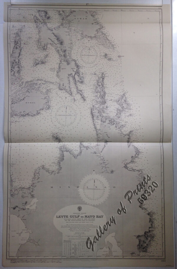 Philippine Islands. Leyte Gulf To Mayo Bay. Including Leyte,Parts of Sebu and Bohol and the North-Eastern Cost of Mindanao. From the United States Cost Survey Charts to 1922.
₱11,000.00
Philippine Islands. Leyte Gulf To Mayo Bay. Including Leyte,Parts of Sebu and Bohol and the North-Eastern Cost of Mindanao. From the United States Cost Survey Charts to 1922.
₱11,000.00
 Philippine Islands. Tagolo Point to Cuyo Islands. Including Sebu Negros and Parts of Panay and Palawan. From the United States Coast Survey Charts to 1923.
₱11,000.00
Philippine Islands. Tagolo Point to Cuyo Islands. Including Sebu Negros and Parts of Panay and Palawan. From the United States Coast Survey Charts to 1923.
₱11,000.00
![Mittheilungen aus Justus Perthes' Geographischer Anstalt über Wichtige neue Erforschungen auf dem Gesammtgebiete der Geographie von Dr. A. Petermann. - Ergänzungsband IV, 1865-1867. Inhalt: [Supplement Vol. 4 contents] No. 16. Dr. A. Petermann, Spitzbergen und die arktische Central-Region. No. 17. Julius Payer, die Adamello-Presanella-Alpen. No. 18. Julius Payer, die Ortler-Alpen (Suden-Gebiet und Monte Cevedale). No. 19. E. Behm, die modernen Verkehrsmittel. Dampfschiffe, Eisenbahnen, Telegraphen. No. 20. P. v. Tschihatscheff's Reisen in Kleinasien und Armenien, 1847-1863.](https://galleryofprints.shop/wp-content/uploads/2022/02/jo12544-Petermann-1860-Mittheilungen-aus-Justus-Perthes-Geographischer-Anstalt-volume-4-600x750.webp) Mittheilungen aus Justus Perthes' Geographischer Anstalt über Wichtige neue Erforschungen auf dem Gesammtgebiete der Geographie von Dr. A. Petermann. - Ergänzungsband IV, 1865-1867. Inhalt: [Supplement Vol. 4 contents] No. 16. Dr. A. Petermann, Spitzbergen und die arktische Central-Region. No. 17. Julius Payer, die Adamello-Presanella-Alpen. No. 18. Julius Payer, die Ortler-Alpen (Suden-Gebiet und Monte Cevedale). No. 19. E. Behm, die modernen Verkehrsmittel. Dampfschiffe, Eisenbahnen, Telegraphen. No. 20. P. v. Tschihatscheff's Reisen in Kleinasien und Armenien, 1847-1863.
₱6,000.00
Mittheilungen aus Justus Perthes' Geographischer Anstalt über Wichtige neue Erforschungen auf dem Gesammtgebiete der Geographie von Dr. A. Petermann. - Ergänzungsband IV, 1865-1867. Inhalt: [Supplement Vol. 4 contents] No. 16. Dr. A. Petermann, Spitzbergen und die arktische Central-Region. No. 17. Julius Payer, die Adamello-Presanella-Alpen. No. 18. Julius Payer, die Ortler-Alpen (Suden-Gebiet und Monte Cevedale). No. 19. E. Behm, die modernen Verkehrsmittel. Dampfschiffe, Eisenbahnen, Telegraphen. No. 20. P. v. Tschihatscheff's Reisen in Kleinasien und Armenien, 1847-1863.
₱6,000.00
![L'Univers. Histoire et Description de Tous Les Peuples.: Océanie [History and Description of the Peoples of the World] Cinquième Partie du Monde. [Fifth Chapter of the World] Tome Troisième [Third Volume]](https://galleryofprints.shop/wp-content/uploads/2021/08/JO12503-Rienzi-1837-LUnivers.-Histoire-et-Description-de-Tous-Les-Peuples-Oceanie-front-scaled-1-600x750.webp) L'Univers. Histoire et Description de Tous Les Peuples.: Océanie [History and Description of the Peoples of the World] Cinquième Partie du Monde. [Fifth Chapter of the World] Tome Troisième [Third Volume]
₱9,900.00
L'Univers. Histoire et Description de Tous Les Peuples.: Océanie [History and Description of the Peoples of the World] Cinquième Partie du Monde. [Fifth Chapter of the World] Tome Troisième [Third Volume]
₱9,900.00
![Cartas de los PP. de la Compañía de Jesús de la Misión de Filipinas Cuaderno 5o [Letters from the Fathers of the Society of Jesus of the Philippine Mission]](https://galleryofprints.shop/wp-content/uploads/2024/05/JO12685-Cartas-de-los-PP-de-la-Compania-de-Jesus-de-la-Mision-de-Filipinas-front-scaled-1-600x750.webp) Cartas de los PP. de la Compañía de Jesús de la Misión de Filipinas Cuaderno 5o [Letters from the Fathers of the Society of Jesus of the Philippine Mission]
₱8,800.00
Cartas de los PP. de la Compañía de Jesús de la Misión de Filipinas Cuaderno 5o [Letters from the Fathers of the Society of Jesus of the Philippine Mission]
₱8,800.00